…WIND ADVISORY REMAINS IN EFFECT UNTIL MIDNIGHT EDT TONIGHT… * WHAT…West winds 15 to 25 mph with gusts 40 to 50 mph. * WHERE…Litchfield County in northwestern Connecticut, the Lake George northern Saratoga Region, southern Adirondacks, mid Hudson Valley and southern Taconics of eastern New York and Bennington and western Windham Counties in southern Vermont.
Special Weather Statement issued April 09 at 3:49PM EDT by NWS
…A LINE OF SHOWERS WILL AFFECT LAMOILLE…WESTERN CALEDONIA…NORTH CENTRAL ORANGE…WESTERN ORLEANS…NORTHEASTERN ADDISON… CHITTENDEN…WASHINGTON AND CENTRAL FRANKLIN COUNTIES… At 347 PM EDT, radar indicated scattered showers located along a line extending from Fairfield to near Lincoln. Movement was east at 35 mph.
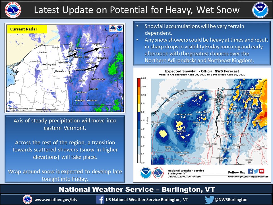
Steady precipitation will shift east before wrap around precipitation will begin tonight into Friday afternoon. Areas of heavy wet, snow in the Northeast Kingdom and in the Northern Adirondacks could make for a few isolated outages and slippery travel. #vtwx #nywxpic.twitter.com/O5M5gBqbN4
Steady precipitation will shift east before wrap around precipitation will begin tonight into Friday afternoon. Areas of heavy wet, snow in the Northeast Kingdom and in the Northern Adirondacks could make for a few isolated outages and slippery travel. #vtwx #nywx pic.twitter.com/O5M5gBqbN4
Source: Twitter NWS Burlington
Winter Weather Advisory issued April 09 at 1:53PM EDT until April 10 at 8:00PM EDT by NWS
…WINTER WEATHER ADVISORY REMAINS IN EFFECT FROM 5 PM THIS AFTERNOON TO 8 PM EDT FRIDAY… * WHAT…Snow expected. Total snow accumulations of 3 to 6 inches. * WHERE…Elevations above 1000 feet in Orleans, Lamoille, Caledonia and Eastern Franklin Counties.
Winter Storm Warning issued April 09 at 1:53PM EDT until April 10 at 8:00PM EDT by NWS
…WINTER STORM WARNING REMAINS IN EFFECT FROM 5 PM THIS AFTERNOON TO 8 PM EDT FRIDAY… * WHAT…Heavy wet snow expected. Total snow accumulations of 6 to 10 inches at elevations above 1000 feet and 2 to 6 inches of snow expected below 1000 feet. * WHERE…Essex County.
Wind Advisory issued April 09 at 11:40AM EDT until April 10 at 12:00AM EDT by NWS
…WIND ADVISORY REMAINS IN EFFECT UNTIL MIDNIGHT EDT TONIGHT… * WHAT…West winds 15 to 30 mph with gusts up to 50 mph expected. * WHERE…Bennington and western Windham Counties in southern Vermont, northwestern Connecticut, eastern New York and western Massachusetts.
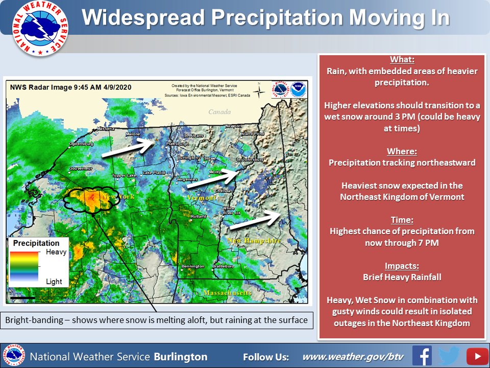
Widespread precipitation is moving into the North Country at this time. It could be heavy at times, with high terrain seeing a transition to wet snow around 3 PM. #vtwx #nywxpic.twitter.com/I2eJ3mTiUu
Widespread precipitation is moving into the North Country at this time. It could be heavy at times, with high terrain seeing a transition to wet snow around 3 PM. #vtwx #nywx pic.twitter.com/I2eJ3mTiUu
Source: Twitter NWS Burlington
While cabin fever may drive you to hit the trail, make sure to remember we’re entering Vermont’s fifth season: MUD SEASON Learn mud season hiking tips, how to check trail closure status, and recommendations for mud season friendly hikes: https://bit.ly/2020VTMudSeason pic.twitter.com/admBGX0sxI
 While cabin fever may drive you to hit the trail, make sure to remember we’re entering Vermont’s fifth season: MUD SEASON
Learn mud season hiking tips, how to check trail closure status, and recommendations for mud season friendly hikes: https://bit.ly/2020VTMudSeason pic.twitter.com/admBGX0sxI
Source: Twitter VT Parks
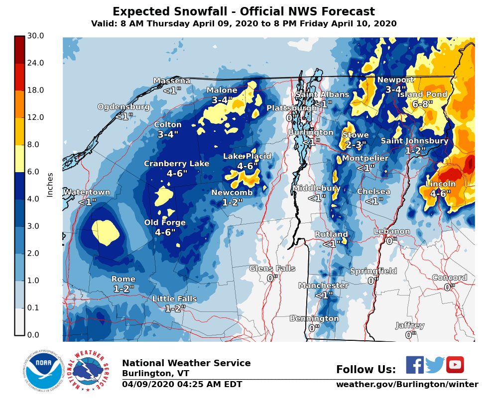
Winter storm warnings and advisories have been issues for north-central/northeastern VT and the northern Adirondacks starting this afternoon and continuing into Friday. Highest accumulations will generally be above 1000 ft. For more info, please visit http://weather.gov/btv/winter .pic.twitter.com/JGmx6DX7zC
Winter storm warnings and advisories have been issues for north-central/northeastern VT and the northern Adirondacks starting this afternoon and continuing into Friday. Highest accumulations will generally be above 1000 ft. For more info, please visit http://weather.gov/btv/winter . pic.twitter.com/JGmx6DX7zC
Source: Twitter NWS Burlington
Winter Weather Advisory issued April 09 at 3:53AM EDT until April 10 at 8:00PM EDT by NWS
…WINTER WEATHER ADVISORY IN EFFECT FROM 5 PM THIS AFTERNOON TO 8 PM EDT FRIDAY… * WHAT…Snow expected. Total snow accumulations of 3 to 6 inches. * WHERE…Elevations above 1000 feet in Orleans, Lamoille, Caledonia and Eastern Franklin Counties.


