Source: Twitter NWS Burlington
Very isolated thunderstorms are expected for the remainder of the daytime, favored across south central Vermont. This forecast of radar reflectivity is just one possible way showers and non-severe thunderstorms will progress overnight into the morning hours. #nywx #vtwx pic.twitter.com/FStruL9rne
Source: Twitter NWS Burlington
Have plans this weekend? Check out your North Country Weather Outlook for this weekend. As always, you can find your detailed forecast at: weather.gov/btv pic.twitter.com/uuCxGmm6jK
Source: Twitter NWS Burlington
Did you know you can get hour-by-hour weather forecasts for your location from NWS? Check out the easy-to-use guide to getting hourly weather forecasts on our website: weather.gov/wrn/hourly-wea…
Source: Twitter NWS Burlington
No matter where you are in the North Country, maximum temperatures from today through Monday will resemble a sine wave as we go on another roller coaster ride. Here’s an example for Vermont’s capital city. #vtwx #nywx pic.twitter.com/r2q0fo2x2t
Source: Twitter NWS Burlington
Interested in becoming a SKYWARN storm spotter? We have a training session scheduled for June 9th at 3 PM. Check out the graphic for more information and the link for registration can be found at weather.gov/btv. We hope to see you there! pic.twitter.com/omEr9gb4Io
Source: Twitter NWS Burlington
Areas of fog, as seen on this webcam of I-91 near Wilder courtesy of VTrans, will burn off this morning. Light rain showers are moving across northern NY & will continue eastward into VT. A slight chance of rain showers are possible through the remainder of the day. pic.twitter.com/XSz8ErYdrE
Source: Twitter NWS Burlington
Each of the next couple of days will be a little bit warmer than the last. Drier weather is also in store with the next chance for rain/thunderstorms late Friday night. pic.twitter.com/S2yrm2kPIN
Source: Twitter NWS Burlington
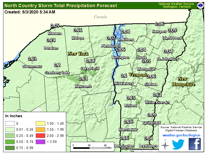
We’re expecting scattered to numerous showers across the North Country, especially this afternoon and evening. Rainfall totals will generally be a quarter inch or less. A warming and drying trend begins on Thursday and continues into Friday. #vtwx #nywxpic.twitter.com/T3s9C1Xnhu
We’re expecting scattered to numerous showers across the North Country, especially this afternoon and evening. Rainfall totals will generally be a quarter inch or less. A warming and drying trend begins on Thursday and continues into Friday. #vtwx #nywx pic.twitter.com/T3s9C1Xnhu
Source: Twitter NWS Burlington
A stationary front separates two airmass from each other. In this case, cool air over the northeast/eastern Canada and hot humid air over the Great Lakes and Ohio Valley. This clash of airmasses will bring continued chance of showers for us and little change in temps Wednesday.pic.twitter.com/pcnKeF5jyr
A stationary front separates two airmass from each other. In this case, cool air over the northeast/eastern Canada and hot humid air over the Great Lakes and Ohio Valley. This clash of airmasses will bring continued chance of showers for us and little change in temps Wednesday. pic.twitter.com/pcnKeF5jyr
Source: Twitter NWS Burlington


